By insideSail
Automated technical check · version 2 ·
Mercator: preserving angles, distorting size
Why a constant bearing can appear as a straight line.
In this guide
Flattening Earth’s curved surface requires a projection. No global transformation preserves all areas, distances, shapes and directions simultaneously.
Mercator preserves angles locally and represents meridians and parallels as perpendicular straight lines. To achieve that relationship, parallel spacing increases towards the poles.
The grid looks simple, but scale is no longer uniform with latitude.
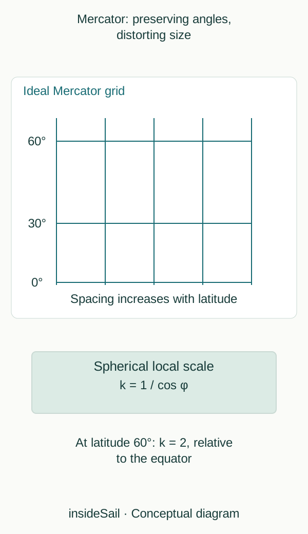
Teaching schematic not to scale; without local data or operational approval.
insideSailOriginal insideSail artwork — all rights reservedEnlarge the diagram
A chart straight line is not the shortest global distance
On Mercator, a line of constant bearing relative to north—a rhumb line—appears straight. That geometrical property is useful for representing courses.
On a sphere, the shorter great-circle arc between two points provides the shortest surface distance. Except in particular cases, it differs from the rhumb line.
A projection property is not a recommendation for selecting a sea route.
Enlargement increases northwards or southwards from the equator. In the spherical model normalised to equatorial scale, the local factor is 1/cos φ.
At latitude 60°, cos 60° = 0.5, giving a factor of 2: a small dimension appears twice as large as at equatorial scale. Physical distance has not doubled.
Real charts declare their reference scale and model; the figure shows the ideal relationship only.
The relationship in numbers
k(φ) = 1 / cos φ
Teaching spherical model; φ is latitude; k is dimensionless.
The projection cannot represent the poles at a finite distance. Nor should Mercator be explained as a photograph made by a lamp at a globe’s centre: it is a mathematical transformation.
Understanding these compromises makes grid and scale legible without giving the chart capabilities its geometry cannot provide. Distance measurement uses a scale appropriate to the segment, developed in the next lesson.
Meridian spacing on the flat grid is uniform, while physical spacing on Earth decreases with latitude. Preserving local angular relationships requires enlargement in the north–south dimension too.
This explains why parallels cannot be equally spaced on Mercator. A small teaching square retains recognisable sides and angles, but its size relative to another distant square changes.
Local conformity does not remove the need to interpret every angle between distant connections. Projection acts point by point; a long line can pass through different scales.
Other projections suit different contexts, including polar regions. Projection choice responds to area and intended use.
Identifying “Mercator” supplies a specific geometrical property rather than universal superiority over other maps.
- Mercator preserves angles locally.
- Scale varies with latitude.
- Rhumb lines and great circles answer different questions.
Concepts in this lesson
Mercator projection
Conformal projection with straight meridians and parallels and scale varying with latitude.
Rhumb line
Line crossing meridians at a constant angle.
Sources and references
- Regulations for International (INT) Charts and Chart Specifications of the IHO — S-4 ↗
International Hydrographic Organization · Edition 4.10.0, March 2026; B-200 mathematical framework; B-300 topography; B-400 hydrography, including soundings and depth contours.
Conceptual facts and standards locator only. No IHO text, chart symbology plate or diagram is reproduced.
Checked on - Boat Crew Handbook — Navigation and Piloting, BCH16114.3 ↗
United States Coast Guard · Chapter 3 A.1–A.5, printed pp.3-2–3-7; B.4–B.6 pp.3-13–3-24; E.8 pp.3-88–3-93.
Selected geometrical concepts only. US procedures, numerical equipment claims and protected artwork excluded.
Checked on - Nautical cartography ↗
NOAA Office of Coast Survey · Map projections; chart scale; cartographic generalisation.
Projection and scale concepts only; US paper-chart policy is not applied to Europe.
Checked on
Keep discovering
The next piece of the puzzle
Discuss this concept
Loading the conversation…