By insideSail
Published without technical review · version 2 ·
Sounding, tidal height and space below the keel
Addition only makes sense when vertical references match.
In this guide
A charted depth refers to a declared vertical plane, the chart datum. Tidal height describes the predicted water surface relative to a reference.
When both use the same datum, adding height and depth gives static water depth in the model. Mixing a height relative to mean sea level with a sounding relative to chart datum can produce correct arithmetic with incompatible references.
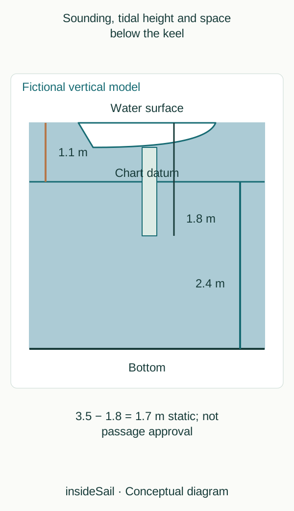
Teaching schematic not to scale; without local data or operational approval.
insideSailOriginal insideSail artwork — all rights reservedEnlarge the diagram
Know the zero before adding
The Portuguese Hydrographic Institute describes Portuguese ZH as a reference below the lowest astronomical tide. Its relationship to mean sea level depends on location.
Other services and charts may use different references. “Chart datum” must not be interpreted as one universal plane.
Positive soundings place the bottom below the reference; drying areas may indicate height above it.
The relationship in numbers
Static water depth = sounding + tidal height Static clearance = static water depth − draught
Metres; same vertical reference; model without dynamic effects.
An astronomical prediction does not automatically include every meteorological effect. Observed level can differ through wind, pressure and local factors.
Nor can local current be obtained from tidal height alone: horizontal movement has its own dynamics. A smooth height curve does not by itself supply an entrance current or slack-water time.
This lesson identifies components and references of a static calculation. It gives no minimum clearance, passage window or interpolation rule.
Those decisions require current local sources, knowledge of the individual vessel and specialist assessment. Tidal oceanography is developed separately without replacing navigation data.
Waterline, lowest vessel point and chart zero are distinct references. An acoustic depth value can include a configured transducer offset.
If it already represents distance below the keel, subtracting draught again duplicates a component. The diagram separates vertical relationships to explain that problem without selecting an installation offset.
System and vessel documentation establish actual context.
Surface height varies through time. Two heights of 1.0 and 2.0 m do not establish a midway height of 1.5 m: development may be nonlinear.
A tide curve has its own form and origin. Arithmetic averaging is no universal interpolation rule.
This lesson therefore demonstrates addition of simultaneous compatible values, without interpolating local tables or choosing an application method.
- Sounding and height need the same datum.
- Astronomical prediction can differ from observed level.
- Geometrical clearance is not a passage decision.
Concepts in this lesson
Chart datum
Vertical reference to which charted depths are expressed.
Tidal current
Horizontal water movement associated with tidal dynamics; not deduced from local height alone.
Tidal height
Water-surface level relative to a declared vertical reference.
Sources and references
- Regulations for International (INT) Charts and Chart Specifications of the IHO — S-4 ↗
International Hydrographic Organization · Edition 4.10.0, March 2026; B-200 mathematical framework; B-300 topography; B-400 hydrography, including soundings and depth contours.
Conceptual facts and standards locator only. No IHO text, chart symbology plate or diagram is reproduced.
Checked on - Zero Hidrográfico (ZH) ↗
Instituto Hidrográfico · ZH definition; depths positive below ZH; relationship to local mean sea level.
Portuguese ZH is described as below the lowest astronomical tide; it is not silently equated with every national chart datum.
Checked on
Keep discovering
The next piece of the puzzle
Discuss this concept
Loading the conversation…