By insideSail
Published without technical review · version 3 ·
A charted mark: symbol, position and attributes
The graphic miniature does not contain all the aid’s information.
In this guide
A buoy at sea and its chart symbol are different things. The buoy has a body, dimensions, mooring and physical condition.
The chart presents an assigned position, symbol and attributes through graphical conventions. Good reading starts by separating these layers: where the aid is represented, what category it identifies and which characteristics are published.
A small silhouette is neither a scale drawing of the buoy nor a measurement of a nearby danger.
From object to record
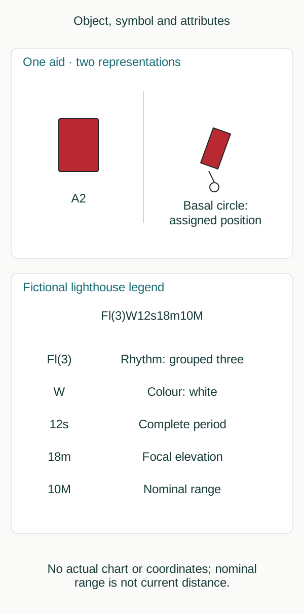
Original schematic without spatial scale; not a chart, route or navigation instruction.
insideSailOriginal insideSail artwork — all rights reservedEnlarge the diagram
Under IHO convention, a buoy symbol includes a small basal position circle; the stylised body can be inclined. Its tip is not a hull coordinate.
Elements can be graphically displaced for chart clarity without changing the location indicated by the appropriate position reference. For isolated danger, aid and hazard need depiction without hiding the obstruction’s position.
Visual distance between symbol bodies therefore cannot be read as actual clearance.
| Field | Fictional example | Information represented |
|---|---|---|
| Name or number | A2 | Particular record identity |
| Category and shape | Can lateral | Family and recognisable form |
| Body colour | Red | Day appearance |
| Light | Fl(2)R6s | Group of two, red, six-second cycle |
| Assigned position | Not supplied in the schematic | Geographical information separate from silhouette |
Fields can be abridged or some may not appear at the selected scale. Shape, topmark, colour and light have their own conventions.
Missing information is not automatically filled with the most common characteristic. This lesson uses original fictional fragments; they contain no coordinates, harbour chart or passing recommendation.
Breaking down a long legend
Small buoy descriptions are often shorter and period may be omitted depending on scale and available space. This does not mean no period exists; it is simply not written in that format.
S-4 also specifies conditions for omitting the white abbreviation. These are chart-production conventions, particularly for paper charts: they do not guarantee that every plotter or app uses exactly the same symbol, colours or information window.
Chart and observation do not update themselves
A floating aid has an assigned position but can move or go off station. Light changes, temporary marks and faults may appear in official notices before a new chart edition.
Edition, updating, scale and information date matter. If a photograph looks green when the record says red, possibilities include misidentification, colour perception, change or outdated information.
A discrepancy calls for evidence, rather than silently replacing the record.
For a first reading, organise the legend into five fields: rhythm, colour, period, elevation and range. Then connect it with the name and symbol.
This prevents the largest number dominating interpretation. Ten miles nominal range, for example, does not place the observer on a position line ten miles away; it is a published light property under reference conditions.
The observer’s position would need independent information. A light description and a position fix answer different questions.
- Position, symbol and attributes answer different questions.
- s, m and M cannot be added: they measure time, elevation and range in this context.
- Do not measure clearance from a chart silhouette.
- A screenshot without edition or date loses part of its provenance.
References: IHO S-4, edition 4.10.0, March 2026, B-460.1, B-461.3(c), B-462–B-466, B-471.2–B-471.8. IALA R1001: family characteristics in 2.1–2.6. No protected symbol plate is reproduced.
Concepts in this lesson
Charted aid
Documentary aid representation with symbol, position and attribute conventions; neither a photograph nor proof of current physical presence.
Educational recognition; provides no route or depth.
Nominal light range
Luminous range under a standardised atmospheric condition; distinct from current observer distance and not guaranteed detection in all conditions.
Educational recognition; provides no route or depth.
Sources and references
- RBMN — artigo 14: Boias de assinalamento de emergência ↗
Diário da República · RBMN annex Article 16; printed p.1981, PDF p.4.
Annex RBMN Article 16, published text 24 June 2016. Commencement follows Portaria Article5; later national interpretation/updates and local directions require qualified checking. Not treated as automatic adoption of IALA2023.
Checked on - IALA R1001 — Regions, conventional direction and lateral identification ↗
IALA · Sections 2.1.1–2.1.5; PDF p.9 onwards; edition 2.0 June 2023.
IALA recommendation, edition 2.0 June 2023, 2.1.1–2.1.5. Consulted edition does not establish individual national effective dates. Publication and jurisdiction require qualified review.
Checked on - RBMN — artigo 3: Método de caracterização das marcas ↗
Diário da República · RBMN annex Article 3; printed p.1979, PDF p.2. RBMN annex Article 6; printed p.1979, PDF p.2. RBMN annex Article 7; printed p.1979, PDF p.2.
Annex RBMN Article 3, published text 24 June 2016. Commencement follows Portaria Article5; later national interpretation/updates and local directions require qualified checking. Not treated as automatic adoption of IALA2023. Annex RBMN Article 6, published text 24 June 2016. Commencement follows Portaria Article5; later national interpretation/updates and local directions require qualified checking. Not treated as automatic adoption of IALA2023. Annex RBMN Article 7, published text 24 June 2016. Commencement follows Portaria Article5; later national interpretation/updates and local directions require qualified checking. Not treated as automatic adoption of IALA2023.
Checked on - Regulations for International (INT) Charts and Chart Specifications of the IHO — S-4 ↗
International Hydrographic Organization · B-460–B-466 buoy characteristics; B-471 light descriptions; B-475.1–B-475.6 sectors and leading lights; PDF pp.306–331 and 336–339.
Official 452-page PDF directly consulted; edition verified against current IHO catalogue. Original educational fragments rather than reproduced INT1 symbol plates. Paper chart conventions are not universal electronic display behaviour.
Checked on - IALA R1001 — Isolated danger and limits of inference about passing distance ↗
IALA · Sections 2.3.1–2.3.2; PDF p.15 onwards; edition 2.0 June 2023.
IALA recommendation, edition 2.0 June 2023, 2.3.1–2.3.2. Consulted edition does not establish individual national effective dates. Publication and jurisdiction require qualified review.
Checked on
Regulatory references
- Isolated danger and limits of inference about passing distance ↗
IALA R1001 edition 2.0 June 2023 · IALA · International recommendation; competent-authority implementation
Verified on - Regions, conventional direction and lateral identification ↗
IALA R1001 edition 2.0 June 2023 · IALA · International recommendation; competent-authority implementation
Verified on - S-4 B-460–466 / B-470–475 — buoy and light charting specifications ↗
IHO S-4 edition 4.10.0 March 2026 · International Hydrographic Organization · International chart-production specification; not a local pilotage rule
Verified on - RBMN artigo 16 — Marcação adicional ↗
Portaria 177/2016, original published annex · Defesa Nacional e Mar; technical direction Direção de Faróis / DGAM · Portugal
Verified on - RBMN artigo 6 — Regras gerais das marcas laterais ↗
Portaria 177/2016, original published annex · Defesa Nacional e Mar; technical direction Direção de Faróis / DGAM · Portugal
Verified on - RBMN artigo 7 — Marcas laterais — região A ↗
Portaria 177/2016, original published annex · Defesa Nacional e Mar; technical direction Direção de Faróis / DGAM · Portugal
Verified on - RBMN artigo 3 — Método de caracterização das marcas ↗
Portaria 177/2016, original published annex · Defesa Nacional e Mar; technical direction Direção de Faróis / DGAM · Portugal
Verified on
Keep discovering
The next piece of the puzzle
Discuss this concept
Loading the conversation…