By insideSail
Published without technical review · version 3 ·
Channels and harbour entrances: combine references without inventing a route
Buoyage, depth, sectors and traffic provide different layers.
In this guide
A harbour approach can combine laterals, safe water, cardinals, leading lines, sector lights and local signals. They do not all convey the same information.
One marks a boundary, another gives a directional reference, another draws attention to a feature. Reading becomes clearer when each layer is assigned the question it actually answers, rather than seeking one colour to resolve the entire approach.
Three complementary layers
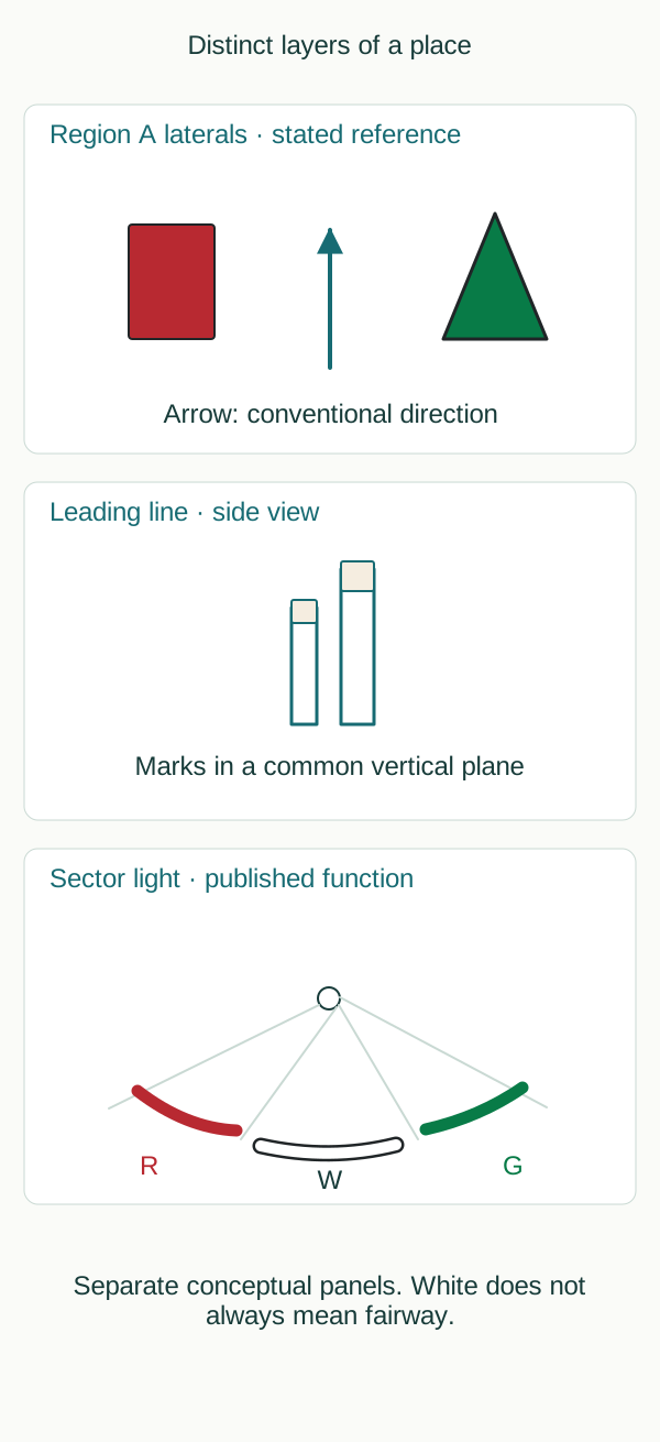
Original schematic without spatial scale; not a chart, route or navigation instruction.
insideSailOriginal insideSail artwork — all rights reservedEnlarge the diagram
| Layer | Question it helps answer | What it does not supply alone |
|---|---|---|
| Lateral marks | Which channel side is this in published direction? | Uniform depth between all marks |
| Leading line | Which line visually relates these references? | Suitability of the entire line for passage |
| Sector light | Which characteristic is seen over that published arc? | Universal meaning of white, red or green |
Laterals depend on region and conventional direction. A channel can have bends, junctions, dredged areas and obstructions; red and green do not draw that entire geometry.
At a junction, a modified lateral can indicate the preferred channel. That designation chooses neither a sailboat’s destination, grants no encounter priority and demonstrates no adequate depth for all draughts.
Collision rules, local traffic rules and buoyage are layers with separate functions.
Why do aligned references help?
A leading line uses two or more marks or lights in a common vertical plane. Their visual relationship allows recognition of the line joining them.
Off that line, the references appear displaced relative to each other; on it, they present the intended alignment. Colours and shapes are chosen by the authority for contrast and identification, rather than necessarily following lateral red/green coding.
Purpose, useful segment and conditions belong to the published information.
Alignment alone does not answer questions about draught, tide, obstructions or position along the line. A geometrical relationship can remain visible before or beyond the segment for which it was established.
This lesson’s figure shows only the relationship between two fixed references, without coordinates, depths or a track. The dedicated leading-line lesson develops the observer’s position.
Sectors are arcs with published meaning
A sector light displays different colours and/or rhythms over designated horizon arcs. It can provide information about a channel, bend, junction, danger or another important feature.
When marking channel limits, colours follow the relevant lateral-system principles. But white is not invariably a deep channel, and red does not imply the same action at every lighthouse.
Angular limits and purpose need publication; the colours in our diagram do not belong to an actual approach.
Their references also differ: a lateral uses conventional direction; a cardinal geographical directions; a leading line relates an observer to two or more references; a sector divides the arcs over which a light is seen. The four can coexist without contradiction.
Stating the reference before interpreting the characteristic is a useful reading habit across all of them. The diagram separates panels to make those functions visible instead of implying a sequence of manoeuvres.
- Connect each aid with its function and reference.
- Do not confuse traffic direction with conventional direction.
- Official notices and local documentation can supplement a chart edition.
- A community observation is a report; it does not replace authoritative pilotage information.
References: IALA R1001, edition 2.0, June 2023, 2.1.1, 2.1.5, 2.7.2–2.7.3 and 3.2.3; Portugal: RBMN, Articles 4, 7, 17 and 18; IHO S-4, B-475.1–B-475.6.
Concepts in this lesson
Leading line
A visual relationship of two or more marks in a common vertical plane with published purpose and characteristics; alignment alone does not guarantee navigability.
Educational recognition; provides no route or depth.
Sector light
A fixed aid with differing characteristics across horizon arcs whose published function and limits determine interpretation; white does not always mean channel.
Educational recognition; provides no route or depth.
Sources and references
- RBMN — artigo 14: Boias de assinalamento de emergência ↗
Diário da República · RBMN annex Article 17; printed p.1981, PDF p.4. RBMN annex Article 18; printed p.1981, PDF p.4. RBMN annex Article 22; printed p.1981, PDF p.4.
Annex RBMN Article 17, published text 24 June 2016. Commencement follows Portaria Article5; later national interpretation/updates and local directions require qualified checking. Not treated as automatic adoption of IALA2023. Annex RBMN Article 18, published text 24 June 2016. Commencement follows Portaria Article5; later national interpretation/updates and local directions require qualified checking. Not treated as automatic adoption of IALA2023. Annex RBMN Article 22, published text 24 June 2016. Commencement follows Portaria Article5; later national interpretation/updates and local directions require qualified checking. Not treated as automatic adoption of IALA2023.
Checked on - IALA R1001 — Regions, conventional direction and lateral identification ↗
IALA · Sections 2.1.1–2.1.5; PDF p.9 onwards; edition 2.0 June 2023.
IALA recommendation, edition 2.0 June 2023, 2.1.1–2.1.5. Consulted edition does not establish individual national effective dates. Publication and jurisdiction require qualified review.
Checked on - IALA R1001 — Lateral marks and preferred channels, Regions A and B ↗
IALA · Sections 2.1.3–2.1.5; PDF p.10 onwards; edition 2.0 June 2023.
IALA recommendation, edition 2.0 June 2023, 2.1.3–2.1.5. Consulted edition does not establish individual national effective dates. Publication and jurisdiction require qualified review.
Checked on - RBMN — artigo 3: Método de caracterização das marcas ↗
Diário da República · RBMN annex Article 4; printed p.1979, PDF p.2. RBMN annex Article 7; printed p.1979, PDF p.2.
Annex RBMN Article 4, published text 24 June 2016. Commencement follows Portaria Article5; later national interpretation/updates and local directions require qualified checking. Not treated as automatic adoption of IALA2023. Annex RBMN Article 7, published text 24 June 2016. Commencement follows Portaria Article5; later national interpretation/updates and local directions require qualified checking. Not treated as automatic adoption of IALA2023.
Checked on - Regulations for International (INT) Charts and Chart Specifications of the IHO — S-4 ↗
International Hydrographic Organization · B-460–B-466 buoy characteristics; B-471 light descriptions; B-475.1–B-475.6 sectors and leading lights; PDF pp.306–331 and 336–339.
Official 452-page PDF directly consulted; edition verified against current IHO catalogue. Original educational fragments rather than reproduced INT1 symbol plates. Paper chart conventions are not universal electronic display behaviour.
Checked on - IALA R1001 — Physical, synthetic and virtual AIS AtoN; local context and synchronisation ↗
IALA · Sections 3.2.1–3.2.4; PDF p.27 onwards; edition 2.0 June 2023.
IALA recommendation, edition 2.0 June 2023, 3.2.1–3.2.4. Consulted edition does not establish individual national effective dates. Publication and jurisdiction require qualified review.
Checked on - IALA R1001 — Lighthouses, leading lines, sector lights and other aids ↗
IALA · Sections 2.7.1–2.7.6; PDF p.21 onwards; edition 2.0 June 2023.
IALA recommendation, edition 2.0 June 2023, 2.7.1–2.7.6. Consulted edition does not establish individual national effective dates. Publication and jurisdiction require qualified review.
Checked on
Regulatory references
- RBMN artigo 7 — Marcas laterais — região A ↗
Portaria 177/2016, original published annex · Defesa Nacional e Mar; technical direction Direção de Faróis / DGAM · Portugal
Verified on - RBMN artigo 18 — Farolim de sectores ↗
Portaria 177/2016, original published annex · Defesa Nacional e Mar; technical direction Direção de Faróis / DGAM · Portugal
Verified on - RBMN artigo 22 — Marcas auxiliares ↗
Portaria 177/2016, original published annex · Defesa Nacional e Mar; technical direction Direção de Faróis / DGAM · Portugal
Verified on - Physical, synthetic and virtual AIS AtoN; local context and synchronisation ↗
IALA R1001 edition 2.0 June 2023 · IALA · International recommendation; competent-authority implementation
Verified on - S-4 B-460–466 / B-470–475 — buoy and light charting specifications ↗
IHO S-4 edition 4.10.0 March 2026 · International Hydrographic Organization · International chart-production specification; not a local pilotage rule
Verified on - Lateral marks and preferred channels, Regions A and B ↗
IALA R1001 edition 2.0 June 2023 · IALA · International recommendation; competent-authority implementation
Verified on - RBMN artigo 17 — Enfiamento e alinhamento ↗
Portaria 177/2016, original published annex · Defesa Nacional e Mar; technical direction Direção de Faróis / DGAM · Portugal
Verified on - Lighthouses, leading lines, sector lights and other aids ↗
IALA R1001 edition 2.0 June 2023 · IALA · International recommendation; competent-authority implementation
Verified on - RBMN artigo 4 — Sentido convencional de balizagem ↗
Portaria 177/2016, original published annex · Defesa Nacional e Mar; technical direction Direção de Faróis / DGAM · Portugal
Verified on - Regions, conventional direction and lateral identification ↗
IALA R1001 edition 2.0 June 2023 · IALA · International recommendation; competent-authority implementation
Verified on
Keep discovering
The next piece of the puzzle
Discuss this concept
Loading the conversation…