By insideSail
Automated technical check · version 2 ·
Air masses and weather fronts
A chart line represents a three-dimensional transition.
In this guide
An air mass is a large body of air with properties related to origin and development, such as temperature and moisture. A front represents a transition between contrasting air masses.
Its chart line is the surface representation of a three-dimensional structure: air is not separated by a thin vertical wall. The transition can have width, slope and development.
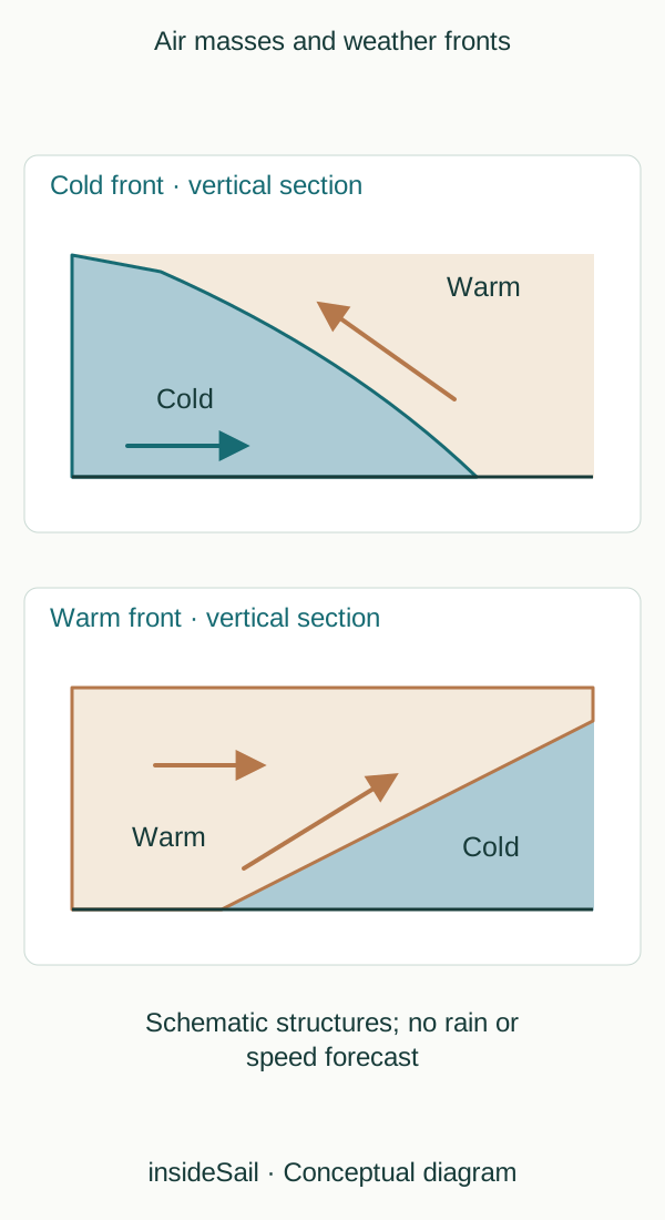
Conceptual schematic not to scale; no local forecast or operational decision.
insideSailOriginal insideSail artwork — all rights reservedEnlarge the diagram
Surface replacement and movement aloft
At a cold front, colder air advances and replaces warmer air near the surface; warm air can be lifted. At a warm front, warmer air advances over a region occupied by colder air along a sloping frontal surface.
Lifting can favour cooling and condensation, but the response depends on moisture and stability. Cold and warm describe relationships between masses rather than an absolute temperature someone expects to feel.
Occlusion involves lifting the warm-air sector as frontal structures develop and meet. A stationary front shows no marked advance of one air mass in the representation considered.
These names supply no universal sequence of cloud, wind and rain everywhere. Latitude, upper-air structure, terrain and system development also matter.
Triangles and semicircles belong to frontal-chart language; their orientation indicates represented advance. This original diagram adds vertical sections with deliberately schematic scales to explain what the line does not show.
Applying a forecast front to a voyage decision needs the full context of weather planning rather than an automatic interpretation rule for this diagram.
Temperature alone does not describe an air mass: moisture and stability modify its response to lifting. Two sectors of similar temperature can have different cloud behaviour when moisture or vertical profiles differ.
Condensation produces droplets or crystals, but precipitation needs further growth and falling processes. “Air rises” is therefore not a complete rain forecast at the observation point.
A frontal line at two times permits comparison of represented positions. Separation divided by time can describe mean pattern displacement in a local model.
It is not air-particle speed: air can cross and circulate within the structure. Pattern, air and observer are different objects.
As with waves, movement of a form should not be confused with transport of the whole medium.
- A front is a transition between air masses.
- A surface line represents a structure aloft.
- Its symbol does not guarantee one weather sequence.
Concepts in this lesson
Cold front
Transition where colder air advances, replacing warmer surface air.
Occluded front
Frontal structure in which the warm sector is lifted as fronts develop and meet.
Warm front
Transition where warmer air advances over a region occupied by colder air.
Weather front
Transition between air masses with contrasting properties.
Sources and references
- Weather fronts ↗
Met Office · Cold, warm and occluded-front definitions; frontal wave explanation.
Conceptual boundaries only; no claim that every front follows the same weather sequence.
Checked on
Keep discovering
The next piece of the puzzle
Discuss this concept
Loading the conversation…