By insideSail
Published without technical review · version 2 ·
Read a marine bulletin alongside a synoptic chart
An annotated example retains area, times, variables and source conventions.
In this guide
A bulletin can compress many variables into a few lines. We unpack an original, entirely fictional example to see what each field adds.
Its wording follows selected conventions used by the British Met Office, but it is not that service’s issue and represents no actual area. A schematic pressure panel supports the reading by showing large-scale context without replacing wind, sea or visibility information.
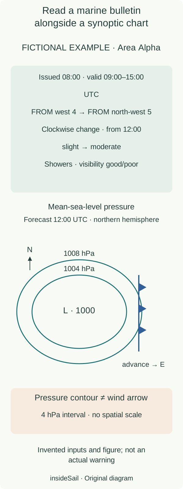
Original schematic. Fictional examples; symbolic visual identification without an operating forecast.
insideSailOriginal insideSail artwork — all rights reservedEnlarge the diagram
1. Unpack the product fields
Area defines spatial scope rather than a GPS point. Issue time says when the product was produced; validity says when the scenario applies.
We wrote “from 12:00” explicitly rather than hide timing in a vague word. Other sources define terms such as later or soon themselves; even one service’s products and fields can use different periods.
Translation must preserve the definition without inventing an exact change time.
| Field | Reading in this example | Does not mean |
|---|---|---|
| Wind FROM west→NW | Origin 270°→315°, clockwise change | Air motion towards NW |
| Force 4→5 | Beaufort classes 11–16→17–21 knots | Maximum gust or constant wind |
| Sea slight→moderate | Height terms from the UK glossary | Largest wave in a sequence |
| Visibility good/poor | >5 NM / 1000 m–2 NM in the glossary | Equal visibility at every position |
2. Do not conflate identical words for different variables
In the chosen glossary, slight corresponds to heights of 0.5–1.25 m and moderate to 1.25–2.5 m. Moderate can also describe visibility, with a different unit and meaning.
Here poor visibility is occasional: the text gives neither location nor duration of each reduction. Intervals define the source’s terminology rather than acceptable conditions for a sailboat.
Do not derive a gust from the mean-wind class or treat the described height as an absolute maximum.
3. Relate pressure without asking the chart for another product
The panel shows a fictional northern-hemisphere forecast of mean-sea-level pressure valid at 12:00 UTC. A central 1000 hPa low is surrounded by 1004 and 1008 hPa contours.
Contour interval is 4 hPa; curves are neither boat tracks nor wind lines. Blue cold-front triangles point in the represented eastward advance direction.
The line summarises a surface transition rather than the precise edge of every shower.
Chart and bulletin can be compared at their shared time but have different resolutions and functions. Isobar spacing informs pressure gradient when scale and interval are known, without determining mast-height wind by itself.
A nearby front adds evolutionary context rather than exact arrival at every point in the area. The example leaves wind in the bulletin and pressure on the chart, preserving each product’s identity.
Warnings are another layer with their own scope and criteria. A service may distribute them separately and update an issue.
Our example has no “no warnings” field, and omission is no guarantee. Read an actual product by identifying service, issue, validity, area, variable, units and glossary; then relate it to other products and updated information.
Applying that set to departure requires vessel and crew context beyond this annotated reading.
- Unpack each field before comparing numbers.
- Retain FROM/TO and issue/validity distinctions.
- Bulletin, chart and warnings contribute different dimensions.
Sources and references
- Marine forecast glossary ↗
Met Office · Wind direction; veering/backing; visibility; sea-state terms.
Terms belong to the specified UK service. All bulletin values and wording are original fictional examples.
Checked on - Coast and sea forecast guide ↗
Met Office · Guide to shipping forecast; guide to inshore waters forecast; product fields and warning distinction.
UK products only. No current forecast, coverage map or transmission schedule copied.
Checked on
Keep discovering
The next piece of the puzzle
Discuss this concept
Loading the conversation…