By insideSail
Published without technical review · version 2 ·
A worked passage record: connect geometry, times and observations
Build a record that retains assumptions and reveals what changed.
In this guide
A list of courses does not tell a voyage’s whole story. This example connects two abstract legs, calculated times, an intermediate observation and vertical references in an annotated record.
It contains no harbour, actual coast or approved track. The concrete learning task is to fill each field, check its arithmetic and distinguish plotted, assumed and observed information.
The ledger retains unanswered questions because geometry alone cannot resolve them.
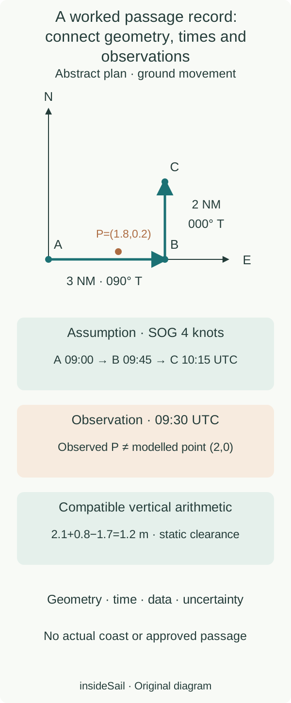
Original fictional constructions for learning. Navigation review pending.
insideSailOriginal insideSail artwork — all rights reservedEnlarge the diagram
1. Define legs and clock
On a local plan, A=(0,0), B=(3,0) and C=(3,2), in nautical miles, with true north upwards. A→B is 3 miles on 090° T; B→C is 2 miles on 000° T.
Assume, for this example, constant SOG of 4 knots on both legs and departure at 09:00 UTC. In each row write duration as distance divided by ground speed.
Calling the 4 knots through-water speed would change the problem if current were present.
| Leg | True course | Distance | Assumed SOG | Ideal duration | Calculated time |
|---|---|---|---|---|---|
| A→B | 090° | 3 NM | 4 kn | 45 min | B 09:45 UTC |
| B→C | 000° | 2 NM | 4 kn | 30 min | C 10:15 UTC |
Total ideal duration is 75 minutes and summed leg distance is 5 miles. Direct A→C distance is √13≈3.606 miles; it cannot replace the sum when calculating this route’s duration.
Arrival times are assumption-based results rather than observations. Retain the plan’s fictional horizontal reference and every input’s origin too.
Actual use requires checking transcription to any other medium while preserving each leg’s direction.
2. Place an observation at its proper time
The record does not turn that difference into a steering order. Movement, initial position, observation origin or other assumptions can contribute.
First identify what diverged and the information quality. Do not automatically use direct distance to B to calculate a navigable arrival: that introduces a new, unassessed line.
A revised timing should state a new model rather than erase the previous assumption as though it never existed.
3. Associate remaining information without conflating it
A teaching bulletin issued at 08:00 UTC and valid 09:00–12:00 temporally covers both modelled legs. That answers validity rather than conditions’ suitability or spatial detail.
Fictional height at C of +0.8 m above D, simultaneous with the time considered, combines with charted depth +2.1 m below D: static depth is 2.9 m. With fictional draught 1.7 m, geometrical clearance would be 1.2 m.
None of these values was observed at an actual destination.
Finally, the ledger retains unresolved fields: chart quality and updates, dangers and restrictions, actual water level, dynamic movement, vessel condition, crew, energy and assessed alternatives. They cannot all be added into a score.
The cited planning framework belongs to the United Kingdom; the lesson does not establish European legal compliance. It teaches an organisation connecting theory with documents while leaving practical assessment to an appropriate context.
- A calculated time retains the speed assumption producing it.
- Record observation and assumption separately.
- Course, vertical access and weather answer complementary questions.
Sources and references
- Zero Hidrográfico (ZH) ↗
Instituto Hidrográfico · Page dated 27 October 2025; definition; positive depths below ZH and negative depths above; local relation to altitude datum.
Actual explanatory text read. No original figure, local offset or port prediction used.
Checked on - MGN 599 (M) Amendment 1 — pleasure vessels guidance ↗
UK Maritime and Coastguard Agency · Updated 10 December 2024; §7.4 voyage-planning context.
UK context only; ledger teaches relationships, not legal compliance or professional approval.
Checked on - Boat Crew Handbook — Navigation and Piloting, BCH16114.3 ↗
United States Coast Guard · Chapter 3 G.9–G.10, pp.3-138–3-140; F.11, pp.3-117–3-122.
DR/EP and distance–speed–time terminology only; current-circle construction is independently derived and numerically checked.
Checked on
Keep discovering
The next piece of the puzzle
Discuss this concept
Loading the conversation…