By insideSail
Published without technical review · version 2 ·
Drying heights and water depth: understand the signs
An elevation above datum enters the depth calculation with the opposite sign.
In this guide
Water-depth arithmetic begins with its zero. The previous lesson added positive charted depth and tidal height.
Now we add seabed above datum, water level below datum and conversion between references. Values are invented, in metres, without a location or tide prediction.
The aim is to read signs correctly and recognise when an algebraic expression no longer represents available water.
Original fictional constructions for learning. Navigation review pending.
insideSailOriginal insideSail artwork — all rights reservedEnlarge the diagram
1. Choose one vertical coordinate
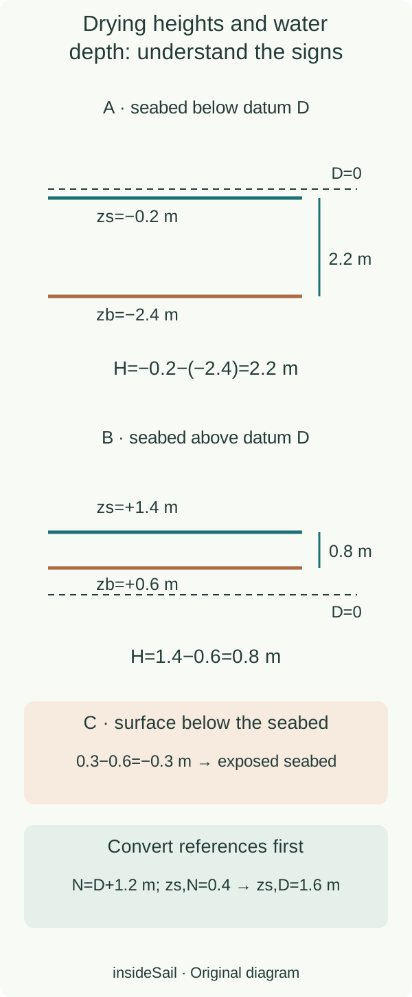
Define z as positive upwards, with z=0 at hypothetical datum D. Seabed coordinate is zb and surface coordinate is zs.
Algebraic surface–seabed separation is H=zs−zb. Positive charted depth d below D gives zb=−d.
Positive seabed elevation e above D gives zb=+e; applicable symbology may present it as a drying height. A positive printed elevation must not be entered as positive depth.
The relationship in numbers
H = zs − zb = h + d = h − e
The last two forms are alternatives: d=−zb; e=+zb for seabed above datum. Metres.
Instituto Hidrográfico explicitly describes positive depths below ZH and negative depths above it. The cited ADMIRALTY document distinguishes drying heights using underlined numbers.
These are documented conventions rather than permission to interpret every underlined number on every map identically. Actual chart legend, units and vertical reference determine interpretation.
Portuguese ZH and LAT are not declared one worldwide plane here.
2. Solve three cases and interpret the result
| Fictional case | Seabed relative to D | Surface relative to D | H |
|---|---|---|---|
| A | −2.4 m | −0.2 m | 2.2 m |
| B | +0.6 m | +1.4 m | 0.8 m |
| C | +0.6 m | +0.3 m | −0.3 m |
In A, negative water height reduces depth: −0.2−(−2.4)=2.2 m. In B, seabed dries 0.6 m above D while water is 1.4 m above it: 1.4−0.6=0.8 m of static water.
In C, 0.3−0.6=−0.3 m is not a column of “negative water”. Seabed stands 0.3 m above the ideal surface and the point is exposed in this model.
Algebra describes geometry; its physical interpretation requires the final reading.
3. Transform references before combining
Subtracting draught produces static geometrical clearance when water exists: H=3.6 m and fictional draught 1.8 m gives 1.8 m. Observed versus predicted level, hydrographic quality, actual draught and dynamic effects remain unevaluated.
No minimum clearance or passage window is supplied. Astronomical prediction, observation and an onboard depth reading have different origins and references; consistent signs do not prove current data.
Overhead clearance can use another zero too. In the cited British document, clearance heights and depths do not automatically share a reference.
Read that field separately: raising water increases depth beneath a keel while potentially reducing space above a mast. Vertical arithmetic must identify both geometries rather than reuse a formula without changing its meaning.
- Draw the zero and declare upwards positive.
- Subtract drying height from compatible water height.
- A negative result can indicate exposed seabed rather than usable water.
Sources and references
- Zero Hidrográfico (ZH) ↗
Instituto Hidrográfico · Page dated 27 October 2025; definition; positive depths below ZH and negative depths above; local relation to altitude datum.
Actual explanatory text read. No original figure, local offset or port prediction used.
Checked on - ADMIRALTY 5606 chart notes — August 2025, version 1.0 ↗
UK Hydrographic Office · PDF page 3 of 15, Notes: depth datum; underlined drying heights; overhead and other height references.
One published document demonstrates that different height fields use different references. No actual local chart, depths, marks or route reused.
Checked on
Keep discovering
The next piece of the puzzle
Discuss this concept
Loading the conversation…